

ArcGIS Server
Discussing the Components of ArcGIS Enterprise: Article 1 - ArcGIS Server
In our previous article we introduced ArcGIS Enterprise and briefly discussed the significant changes that this software brings to the world of GIS, and how Acorn Information Solutions (AIS) launched its MonARC Data Migration Solution to help corporations migrate to this new generation of GIS.
Today we will discuss the first major component of ArcGIS Enterprise: ArcGIS Server.
ArcGIS Server is the back-end server software that allows users to create and access GIS data anywhere with an internet connection. This is accomplished through web services. Web services can be accessed in a variety of ways including directly in a web browser without the need for installing special software.
Field workers can access these map services on tablets or smart phones using ESRI’s line of intuitive and powerful mobile apps, that are included in the ArcGIS Enterprise software licensing.
Advanced GIS users can also access these map services with ESRI’s premier desktop mapping and analysis software – ArcGIS Pro.
ArcGIS Server comes in three different editions; Basic, Standard and Advanced. Each edition offers a different level of functionality that include many parts of a server-based GIS. Below we detail a few of the most important tools that are included:
- Server Manager - used to administer the server, including activities such as adding or removing services, organizing services, setting up security rules, viewing server logs and defining security roles.
- Caching Controllers and Tools - used to tune the performance of your map and image services.
- Geometry Service - used to aid applications to perform geometric calculations such as buffering, simplifying, calculating areas and lengths. Additionally, the ArcGIS Web APIs use the geometry service to create and modify feature geometries during web editing.
- Printing Tools - a service that can be used to print maps from custom web apps.
- Synch Tools - can enable a sync capability on feature services, which allow clients to download a local copy of the data to use when offline and synchronize changes between the client and feature service when the client is back online.
- GeoAnalytics Tools support big data feature analysis in ArcGIS GeoAnalytics Server.
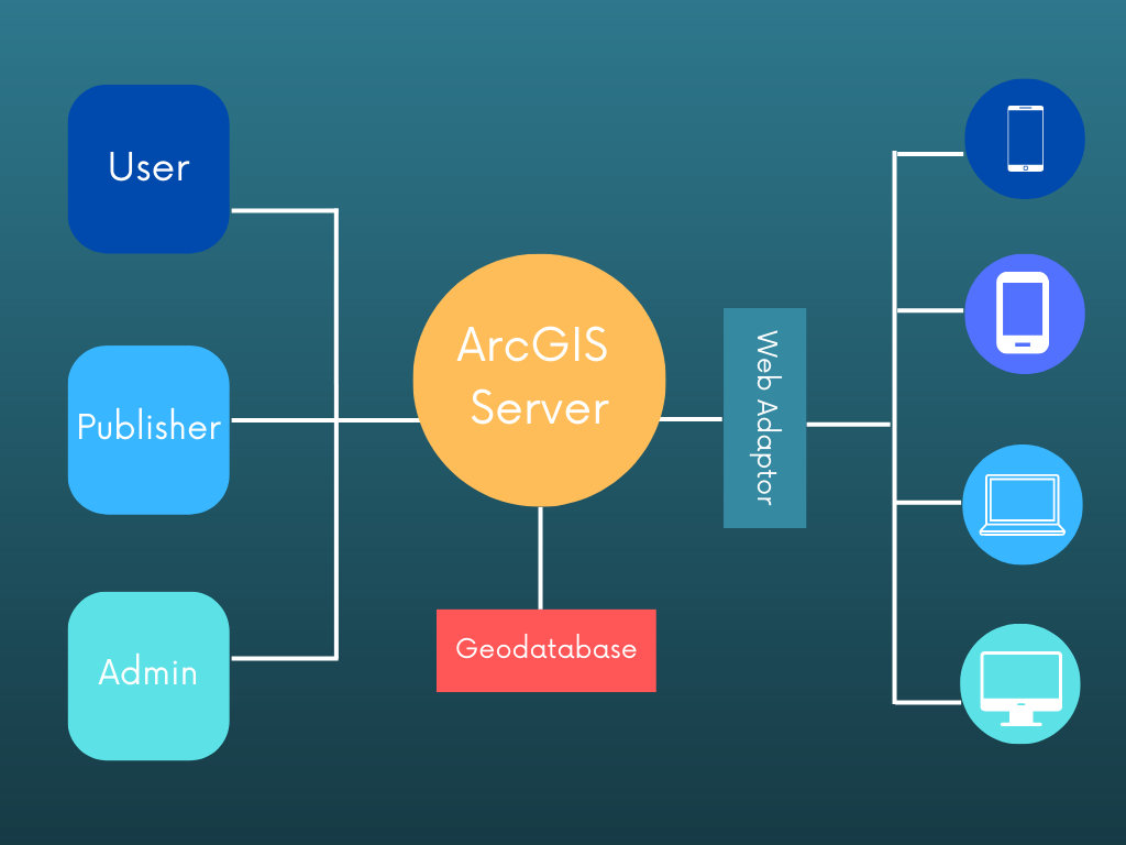
ArcGIS Server can be configured as federated with ArcGIS Enterprise Portal or stand-alone. It is a scalable solution so multiple machines can be added when needed. It can also be installed on virtual machines or commercial cloud platforms.
Advancements in ArcGIS Server have extended the reach of an entire corporate GIS to anyone with an internet connection. The interface used to access and interact with corporate GIS data is now tailored to the specific role of users. Gone are the days of rolling out a thick GIS client to all users. Now, fields users can use apps, while intermediate users can use browser-based maps, and GIS professionals can use ArcGIS Pro. IT departments can better accommodate an individual user form factor preferences, and this diverse user base can all be reached with the same map services.
ArcGIS Server provides a robust reach to corporate GIS datasets and the ability to craft interfaces tuned to the user base. But this capability also requires knowledge on how to set up, optimize and maintain the performance needed. As a GIS user base grows, it will place increased strain on resources and performance. We have extensive experience helping clients plan, install and maintain ArcGIS Server environments.
After the ArcGIS Server environment is in place the GIS site administrator will need to focus on the next component of ArcGIS Enterprise: ArcGIS Web Adaptor, and that will be our next topic.
Follow us on LinkedIn to be notified as we continue this series of Introduction to ArcGIS Enterprise.
About the Author
Craig Martin is Acorn’s Municipal and GIS Manager and has over 25 years of experience in the field of GIS. Craig has extensive experience in data modeling, data capture, administration, solutions architecture, and smart data networks in a variety of engineering disciplines. Connect with one of our experts at info@acorninfosolutions.ca